Itinerary T2 - Gocek - Marmaris - Gocek ( 1 week )
Turkey & Itineraries |
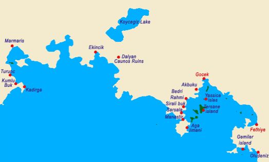
PLACES YOU CAN SEE IN THIS PROGRAM
Gocek
Gulf of Fethiye
Aga Limani
Gobun Bay There is a cozy little bay between Göbün Koyu and Yavansu Koyu, sandwiched between two mountains, called ‘Merdivenli Koyu’ by the local villagers. The small beach inside the steep rocks on either side of the bay is very impressive. The cave situated behind the beach can be reached by climbing over some high steps. It must be because of these steps that the bay was called ‘Merdivenli Koyu.’
Manastir Bay The S quadrant of the bay, where there is an island as well as remnants of a Roman bath, is considered to be an ideal spot to anchor as it remains calm in stormy weather. It is a comfortably nice place to spend the night as long as there is no wind blowing. In the W part of Manastir Koyu is an old, long wall that runs by a restaurant called Wallbay. This wall was built to protect Lydae at the top of the isthmus and its village Arymaxa. From here it extends up to the hill and then back down to the sea again. Thusly, the peninsula was securely cut off from the mainland. When you get to the top of the hill the beautiful view of Gokgemile Koyu is going to amaze you. The shoals off the coast are like a motif of the panoramic view.
Sarsala - Sirali Buk There are a number of small coves in this bay, which is exposed to the 5, whereas some vessels drop anchor in these coves. There is a mountain path behind these on which one can trek up to Erentepe and Kocagöl. Kocagöl is 2 - 3 km. beyond Sarsala. Here the ancient city of Lyssa is situated at Kizilagaç Mevkii. The only author of antiquity to have ever mentioned this city was Pliny. It is known that the city did not mint any coins but it was mentioned in inscriptions. A part of the acropolis walls remains standing, whereas there are inscriptions on the S side of the walls. These are honor inscriptions that were written in the 3rd century B.C. during the period of Ptolemiac Dynasty. Nothing much remains of the ancient city save for tombs that are seen between the city and the sea. However, as with other cities of antiquity, there most certainly should have been ruins of some private and official buildings as well. The other name of Sirali Bükü, which is located in the inlet of Martin Burnu to the N of Sarsala Pier, is Martin Koyu. The bay is surrounded by tall mountains and unites with the pine trees growing on the peaks. It is possible to moor anywhere along the cape, which has five beaches.
Bedri Rahmi Cove There is a freshwater fountain under some immense pine trees at the NE end of this wide bay, which poses no problems as far as entering it is concerned. You can drop anchor at a depth of 2 —2.5 m. at the spot where a restaurant and a pier are located, and replenish your water supply at the fountain at the same time. You can see Bedri Rahmi’s picture of a fish right behind this fountain and just behind it is a Lycian rock tomb seemingly lurking amongst the trees. In addition to this tomb, there are numerous Lycian pigeon-hole tombs carved into the face of a [arge rock. In addition, one can encounter a rock tomb with an embroidered gate as well as three tombs lying next to each other further on ahead. These rock tombs are peculiar to the Lycians in that they reflect examples of their wooden edifices. These rock tombs, of which we have seen several examples in Caunos, with more to be seen in Fethiye and Myra, date to the 4th-5th centuries B.C. and belong to the ancient city of Crya, located up on the hill.
Tersane Island We know that Tersane Adasi, which used to be known as Telandria, was inhabited during ancient times.However, there are a total of 140 dilapidated houses on land as well as submerged in the sea that catch one’s eye. These houses belonged to the island’s inhabitants who emigrated to Rhodes in 1923. There are ruins of two churches, one adjacent to the well and the other on the hill, as well as the graves of the ancient people’s community leaders in the W. The island derived its name from the fact that the Ottoman naval fleet used it as a shipyard during World War I. Before the population exchange, the people here were known to be involved with raising fruit orchards and animal husbandry. Again, you can still encounter fruit orchards and goat herds.
Yassica Isles
Ak Bükü
Fethiye The significance of the city, which continued its existence into the Byzantine era, waned with the Arabian raids which occurred after the 7th century. The city’s name was changed to Anastasiupolis during the 8th century in honor of the Byzantine Emperor Anastasiupolis II, whereby the following century this too gave way to the Makri, which meant ‘far city.’ Later on, the city was called Megri, whereas Megri was finally changed to today’s Fethiye in 1934, to commemorate one of the first Turkish aviators, Fethi Bey. C. Texier, who saw Telmessos in the 1850’s, indicated that the Apollo Temple and theater could be seen at that time. Not long after C.Texier’s visit, a major earthquake struck in 1856, which knocked down these structures, and when Fethiye was hit with a second devastating quake just over 100 years later, in 1957, these ruins were completely destroyed. Today’s Fethiye is what was built up after this second temblor more than forty years ago. Today, the theater, which was found near the pier of new Fethiye, has been uncovered. This theater, which had the capacity to hold 5,000 people, was built in the Early Roman Period and renovated later in the 2nd century A.D. A medieval castle situated on the acropolis hill, where the city was first established, is surrounded by a wall. Today, one can see the bottom portion of this wall, which was erected by the Romans as well as the upper part, which was constructed during the Middle Ages, when the Rhodian Knights used this castle as well as Sövalye Adasi, located in the harbor, to hold the city under their control. The Tomb of Amyntas, which is the most splendid and best known of all the tombs, is located on the E face of the city’s acropolis and has become the symbol of Fethiye. Seen from the plain below, it gives a great impression of size from up close. It is of the temple-type, in the Ionian order. Four steps lead up to the porch with two columns between pilasters; halfway up the left-hand pilaster the name of Amyntas, son of Hermapias is inscribed in letters of the 4th century B.C. Encountering this tomb in the 1850’s, C. Texier apparently wished to document this as he signed the upper left corner of the grave door. In the cliff-face further to the left are numerous other tombs; two of these are temple-tombs similar to that of Amyntas, and little less impressive. There are also a number of Lycian-type sarcophagi within the city. One of these is situated on the street directly below these stone monuments, while the other stands besides the municipal building near the pier. The sarcophagus next to the municipal building is one of the few sarcophagi with reliefs that has managed to remain intact to the present. Both sides of the lid and of the surmounting Crest carry reliefs showing rows of warriors with shields in their hands, with a man sitting in an armchair wearing long clothing on the right side. The ends of the lid are divided into four panels. This sarcophagus, which was erected in ca. 340 B.C., once had reliefs on the bottom part as well, which is understood from the drawings of both Sir Charles Fellows and C.Texier. In addition, there are two sarcophagi from the 4th Century that are located in the Cumhuriyet District, one of which has reliefs. However, these reliefs are in poor condition.
Kayakoy
Ekincik If by any chance you can find a place for you and your mates in this bay of blues and greens, anchoring here is going to be both secure and enjoyable. Those daily excursion motorboats out of Marmaris only go as far as Delik Adasi, where the Dalyan Stream flows into the sea. From here you’ll board another motorboat that takes you to Caunos along a very shallow channel that resembles a dreamworld. The channel, which twists and winds its way all the way up to Köycegiz Gölü, takes on another meaning with magnificent scenery of the reedy marshes and Lycian rock tombs. After wandering around the Caunos ruins and visiting the curative mud baths, the romantic return to the sea is bound to remain etched in your memories for the rest of your lives. Dalyan / Caunos (optional trip to Dalyan - mud baths, turtlesand ruins of Caunos) Situated on the border of ancient Lycia and Caria, Caunos receives much attention today for the fact that it is very close to where the giant loggerhead turtle Caretta Caretta goes ashore to deposit its eggs, for its Lyciantype tombs, for its Venetian-like channel and most importantly for its ruins. As the taxi boat winds its way through the channel up to Caunos, you will suddenly come face to face with several magnificent Lycian-type rock tombs. There are three stone beds inside the tombs in which the deceased were placed. From the fragments of earthenware uncovered, the tombs have been dated to the 4th century B.C. One of the three of four inscriptions that were found just above these tombs, contains two words related to the Carian language, while it is understood that the other tombs were recycled during the Roman Period. The facades of the tombs, which were carved out of the sheer rock have two columns of the Ionian order. On top of the columns, you’ll see exterior friezes above pediments which were decorated with acroters in three corners. Most of the columns are no longer intact. Of the pediments, all but one is plain, with a unique example of a relief of two lions positioned face-to-face. To the side of this incredible group of tombs is yet another tomb, which is plainer, and incomplete. On the W end of this group of tombs, which is near the village, are more Carian-type tombs which were not decorated like the others. In addition, there are niches that were opened on the lower rock surface for votive offerings. The name Dalyan’ means fishery, and a complicated system of barriers has been built among the reeds to allow the gray mullet and sea bass to be caught as they head for the sea. Let’s go ashore at the landing next to the fishery and wander around the ruins. The first thing we see is the acropolis of Caunos, which rises 152 m. high over a cliff in the S quadrant. The fortification walls situated in the N quadrant appear to be from the Middle Ages. This trip will be absolutely your favorite because it offers you such variety. Experience beautiful scenery while cruisig through the Dalyan river marshes. Passing the famous Caunos rock tombs and ruins before arriving the mud baths. Here you have a chance to pamper yourself in the mud and sulphur pools and will feel the wrinkles dissaoearing! Now feeling cleansed and fresh you are ready for a riverside lunch stop and perhaps a beer or two! After lunch drift down the river again to relax, soak up the sun, swim and share the same beach space as the Caretta Caretta turtles who still breed here.
Marmaris Among the few historical buildings found in Marmaris today, are a castle, which was built in 1557 and recently restored, a mosque in Kemeralti District, which was built by Mengelizade Ibrahim Aga in 1789 as well as a caravanserai which was constructed in 1545. This stone inn with brick vaults was erected on the road to Mugla during the reign of Süleyman the Magnificent in the military campaign against Rhodes. Located near the old junior high school is the Degirmen Brook Bridge, which was also erected during the time of Süleyman the Magnificent. If you have the time, we recommend that you check out Sedir Adasi, as well as Karacasögüt, where you can see ancient theaters, temples and fortification walls. As you come out the bay, your boat will manuever past Keci Adasi and Yildiz Adasi, otherwise known as Nimara to call on Alkaya Cave. Then you will sail out to Kumlubük where to take a break of a couple of hours for lunch and an afternoon swim in the sea. Straight up from the pier are the Amos Ruins, which are situated on Asartepe. With its styrax forest in the middle of the city, excursion trips taken with motorboats and its natural beauty, Marmaris is an ideal spot for rest and relaxation. In addition, the town, which is complimented with wonderful nearby bays such as Sedir Adasi, Karacasögüt, Mersincik, Hisarönü, is a paradise on earth.    |
|